S42.4: Methods for multiple-scale analysis of crane habitat
Amy L. Richert1, Kevin E. Church2 & Scott E. Richert3
1Department of Geography, 302 Avery Hall, University of Nebraska-Lincoln, Lincoln, Nebraska, 68588-0135,USA, arichert@unlinfo.unl.edu; 2Wildlife Division, Nebraska Game and Parks Commission, 2200 N. 33rd Street, PO Box 30370, Lincoln, Nebraska, 68503-0370, USA, kchurch@ngpsun.ngpc.state.ne.us; 3Lancaster County Assessors Office, 555 S 10th Street, Lincoln, Nebraska, 68508-2864, USA, srichert@netinfo.ci.lincoln.ne.us
Richert, A.L., Church, K.E. & Richert, S.E. 1999. Methods for multiple-scale analysis of crane habitat. In: Adams, N.J. & Slotow, R.H. (eds) Proc. 22 Int. Ornithol. Congr., Durban: 2544-2551. Johannesburg: BirdLife South Africa.We studied multiple-scale habitat associated with observations of the endangered Whooping Crane Grus americana, in Nebraska, USA. Specifically, we studied methods for analysing relationships between night-roosts and habitat data obtained from colour infrared aerial photographs and Thematic Mapper satellite imagery. We found satellite data most suitable for delineation of important habitat variables for crane research. We present recommendations for multiple-scale analyses of other cranes.
INTRODUCTION
Understanding a species' habitat requirements is basic to its conservation. Research summaries show that most studies of crane (Gruidae) ecology have emphasised habitat selection at a local scale (e.g., <10 ha) (Johnsgard 1983; Meine & Archibald 1996). However, a few studies have suggested cranes may be responding to landscape patterns or features at distances beyond what is typically examined (Howe 1989; Hirat et al. 1995). In addition, large scale (e.g., >100 ha) patterns of habitat use are readily depicted by plotting crane observations (Allen 1952; Iverson et al. 1985; Hirat et al. 1995), further suggesting cranes may select habitat at multiple spatial scales.
Several methods are available for assessing habitat selection, and choosing the most appropriate technique can greatly influence the results (Porter & Church 1987; Aebisher et al. 1993). Considerations for applying a particular technique include the type of crane population or habitat use data, statistical assumptions and limitations, and the availability of accurate land cover or habitat information. For many areas of the world, remotely sensed imagery offers the most efficient way to create a database for conducting habitat studies over large or isolated areas often used by cranes (Anderson et al. 1980; Jensen 1996). Although previous researchers have used remote sensing to study cranes (Herr & Queen 1993; Baker et al. 1995), a general description of techniques for determining habitat selection at multiple spatial scales is lacking. This paper: (1) discusses the development of a database from remotely sensed imagery, (2) describes the approach we used for analysing Whooping Crane (Grus americana) stopover habitat at multiple spatial scales, and (3) makes recommendations for similar work on cranes elsewhere.
METHODS
We created a Geographic Information Systems (GIS) database of all reported sightings of Whooping Crane in the state of Nebraska from 1975-1996. The two regions with the highest densities of reported Whooping Crane night roost locations were selected for our study areas (i.e., Central Platte River area [CPR], and the Central Table Playas area [CTP]). Each roost location was then buffered to 2160 m and the specific boundaries of each study area was delineated by drawing the smallest convex polygon that encompassed all buffers. The CPR area included a 90-km reach of the Platte River consisting of several shallow-water channels within a forested floodplain surrounded mostly by cropland. The landscape pattern within this study area was aggregated (Porter & Church 1987). The CTP area was a dissected table lands used mostly for ranching and crop agriculture. On this area, wetlands consisted of wind blown-depressions with water levels that were closely related to climatic conditions, and the general landscape pattern was much more even or regularly distributed than the CPR.
Database development
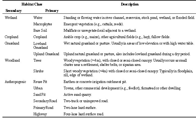
For each study area, a GIS database was constructed consisting of whooping crane roost locations, land cover information from remotely sensed imagery, and ancillary roads data. A habitat classification scheme was developed based on features considered important for Whooping Crane (Lingle et al. 1984, 1987; Armbruster 1990). The sample size of roost locations (n = 44) was limited, so we used only five secondary habitat classes (independent variables), which were generalised from primary classes (Table 1). We used only night roost locations, so the identification and delineation of wetlands were particularly important.
Two vector-based habitat data layers were created from colour infrared (CIR) aerial photographs by delineating polygons on acetate overlays and digitising their boundaries into the GIS database. Habitat data delineated from 31 May and 13 July 1981 aerial photographs (National High Altitude Photography Program [NHAP] 1:60000) represented habitat conditions for the time period 1975-1984. A second habitat layer from aerial photographs dated 13 May, 28 July, 13 August 1988 (National Aerial Photography Program [NAPP] 1:40000 scale), represented habitat conditions for the time period 1985 to 1990.
Last, a third data layer was obtained by digitally processing the red visible (TM3), near (TM4), and middle infrared (TM5, TM7) bands of raster-based Landsat 5 Thematic Mapper satellite imagery dated 4 August 1992 and 28 July 1993 for depicting habitat conditions during the period 1991to 1996. On-screen digitising was used to subset irregular shaped landscape features (e.g., palustrine wetlands, riverine areas) from regular-shaped landscape features (e.g., agricultural fields) (Narumalani et al. 1998). Within subset images pixels were grouped according to spectral properties using an unsupervised clustering algorithm (Jensen 1996). Clusters (spectral classes) that fit into easily identified information classes were labelled. Clusters with mixed spectral properties (e.g., contained properties associated with open water and woodland, or bare ground and urban) were subjected to two levels of iterative unsupervised 'cluster-busting' (Jensen 1996).
Each vector- and raster-based habitat data layer was overlaid with road location information obtained from the United States Bureau of Census 1990 Topologically Integrated Geographic Encoding and Referencing (TIGER) files. Overall classification accuracy was assessed by inspecting large scale photographs (i.e., 1:4000 scale) and ground truthing over at least 10% of each study area.
The Whooping Crane roost location data were subset into three temporal layers (1975 to 1984, 1985 to 1990, 1991 to 1996). These data were overlaid with the corresponding habitat layer.
Analysis of habitat selection
Habitat composition (percent land area within each habitat category) was determined for the extent of each study area, and for the land areas surrounding each roost location at three spatial scales (small [<240 m], medium [240 to 1200 m], and large [1200 to 2160 m] distances from the center of a roost location). A roost location was defined as the center of the wetland in which a crane was
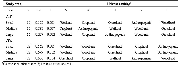
Aknown@ to night-roost.Compositional analysis was used to assess habitat selection at each scale by comparing habitat use (habitat composition surrounding each roost site) to habitat availability (habitat composition within a study area) (Aebischer et al. 1993). In the absence of habitat selection, there is no difference between available and used habitat compositions. This hypothesis was tested for each scale (small, medium, large) using multivariate analysis of variance (MANOVA). When the null hypothesis was rejected (P<0.05) the relative preference of particular habitats was ranked (Aebischer et al. 1993).
RESULTS
Database development
Overall classification accuracy was 98% for data layers made from the 1:40000 CIR photographs and 90% from 1:60000 CIR photographs. Satellite imagery was classified with an 86% overall accuracy. Dissimilarities noted between maps made by aerial photographs and satellite-derived classified images resulted primarily from differences in spatial and spectral resolution of raw data (Table 2). Aerial photograph data provided the most detailed information, whereas satellite data had the coarsest spatial resolution and produced the least detailed habitat maps.
Most errors in delineating both sets of aerial photographs occurred by misclassifying shrubs as macrophytes within the Platte River and by omitting small patches of grasslands that were labeled as cropland. It was difficult to discern shelterbelts from wooded farmsteads at the 1:60000 scale, so some urban patches (farmsteads) were mislabelled as woodland.
Prior to subsetting irregular-shaped features from the raw image, some wetlands were omitted because wet soils were confused with irrigated cropland. By separating irregular-shaped features from cropland prior to clustering, classification accuracy of satellite data increased by 12%. Remaining errors in the classified image were associated mostly with mislabelling riverine shrubs as macrophytes and sparse grass cover as fallow. Open water was easily detected and mapped with use of TM infrared bands. Some open water areas measured <30 m at the time of sensor overpass, but were larger during migration season. The most accurate way to depict wetlands was to include open water, associated mudflats, and macrophytes (Table 1). The best representation of grasslands resulted from placing wet meadows and upland grasslands into a grassland class.
Percent composition of roads and wetlands differed markedly between satellite- and aerial-derived maps. Roads and shelterbelts consumed more area on rasterised maps, which tend to distort linear-shaped features. Development of data layers from aerial photographs required more than twice the time needed to process digital images. The 1981 (1:40000 scale) and 1988 (1:60000 scale) habitat data layers contained 8631 and 9514 polygons, respectively.
Analysis of habitat selection
Whooping cranes selected habitat at each scale studied (Table 3). Wetlands were an important habitat component at all spatial scales. At a small scale, anthropogenic habitats were avoided. In general, rankings were inconsistent between study areas. For example, woodlands were ranked as preferred in the CPR study area, but were ranked as avoided in the CTP. Cropland was preferred over grasslands in the CTP but the opposite occurred in the CPR.
DISCUSSION
Recommendations for remote sensing of crane habitat
Large-scale vector-based imagery provided the most detailed habitat information and therefore would most likely be preferred by ecologists for use in habitat selection studies. However, all classified images provided acceptable overall accuracy levels (Jensen 1996), meaning that habitat maps were suitable for use at all spatial scales we examined.
When selecting imagery for habitat studies, a general rule is to choose the remote sensing tool that is most cost-efficient, but also is suitable for meeting study objectives. Usually, this involves imagery that covers a large on-ground area but has coarse spatial resolution. The smaller scale photography we used (1:60000 scale) was the least expensive. However, use of satellite imagery was most cost-efficient because it required much less time to process. The amount of time to hand-digitise information from aerial photographs increases as the number of habitat patches increases. Our study areas contained numerous small, isolated habitat patches that were labour intensive to digitise, label, and edit when derived from aerial photographs. In contrast, our digital image processing techniques classified patches of similar spectral reflectance over the entire area as soon as a representative reflectance values were identified. It is important to note that in many areas of the world, ancillary data in digital form are unavailable or difficult to obtain. Without availability of such data, use of aerial photography becomes less cost efficient.
Researchers should also consider complexities associated with processing data when selecting remote sensing tools. Most ecologists are not trained in remote sensing and therefore more comfortable with processing imagery visually (use of photographs) than spectrally (use of satellite data). Classification accuracy with satellite data is closely related to expertise in remote sensing (i.e. integration with GIS, use of special transformations, and statistical analyses of multiple data layers) (Jensen 1996; Narumalani et al. 1998). We found that use of such techniques was advantageous for delineating the five secondary habitat classes identified as important to Whooping Cranes.
Use of aerial photography most accurately identified woodland, cropland, and urban areas. However, most cranes use open water environments for nesting or roosting which are most easily identified with infrared bands associated with satellite imagery. Previous concerns about use of satellite imagery for local scale habitat assessments focused on limitations in detecting small open water areas especially in regions with high seasonal and annual climatic variation (Gilmer et al. 1980, Kuzila et al. 1991, Jensen 1996). However, most Whooping Cranes roosted in wetlands that were larger than the minimum mapping unit of Thematic Mapper imagery. Furthermore, the classification scheme we used provided sufficient recognition of wet areas even during dry periods because mudflats adjacent to small open areas were included in the wetland class.
Spatial analysis
Our findings concur with other researchers (Allen 1952; Lingle et al. 1987; Armbruster 1990) that at a small scale, Whooping Crane prefer wetlands. Other preferences were more difficult to interpret because of differences in landscape patterns between study areas. For example, the CPR study area had an aggregated landscape pattern with woodlands adjacent to wetlands (i.e., river channels). Therefore, preferences for wetlands would result in selection of woodlands by association.
Other methods for detecting habitat selection include comparisons between habitat composition around used sites to habitat composition around sites not used (Baker et al. 1995), or comparisons between used sites and random locations (Meyer et al. 1998). An advantage of these tests is that comparisons are made between areas of similar spatial scale and landscape patterns, and thus these factors do not influence inferences of habitat selection. This method was not appropriate for our purposes because (1) the sample size of Whooping Crane observations was limited, (2) the number of companion random sites would not have adequately characterised available habitat, and (3) it was not possible to select sites not used, since Whooping Crane sightings are based on a biased probability of detection.
Our results are valuable for understanding the utility of compositional analysis for studies of crane habitat selection. We found that Whooping Cranes select habitat at spatial scales not previously studied and that some trends in habitat preferences occur. However, we suggest caution when interpreting results since landscape patterns influence inferences of habitat selection (Porter & Church 1987, Turner et al. 1989). Furthermore, researchers should consider designing studies to test for habitat preferences over a range of landscape patterns used by cranes.
Although most studies of crane habitat are conducted at a site level, additional information may be gained by inspecting habitat requirements at multiple spatial scales. We recommend use of satellite imagery for cost-effective multiple-scale research because of advantages associated with digital image processing including multispectral resolution, easy integration with GIS analyses, and efficient reuse of raw imagery for other projects. Last, we recommend using compositional analysis with the habitat classification scheme we used because it is applicable for crane habitat in general, and is well suited circumstances under which many crane habitat studies are conducted.
ACKNOWLEDGEMENTS
This project was supported by the Biological Resources Division of the United States Geological Survey and the Nebraska Game and Parks Commission. We thank George Archibald and the International Crane Foundation for the invitation to present this work in the Advances in Crane Research symposium and for financial and logistical support for the senior author to attend the XXII International Ornithological Congress meeting in Durban, South Africa. We also thank J. Scott Taylor for his help in data analysis.
REFERENCES
Aebischer, N.J., Robertson, P.A. & Kenward, R.E. 1993. Compositional analysis of habitat use from animal radio-tracking data. Ecology 74: 1313-1325.
Allen, R.P. 1952. The Whooping Crane. Research report number 3. New York: National Audubon Society, 246 pp.
Anderson, W.H., Wentz, W.A. & Treadwell, B.D. 1980. A guide to remote sensing information for wildlife biologists. In: Mosby, H.S. (ed) Wildlife management techniques manual, 4th ed.; Washington, D.C.; The Wildlife Society.
Armbruster, M.J. 1990.Characterization of habitat used by Whooping Cranes during migration. United States Department of the Interior, Fish and Wildlife Service. Biological Report 90:1-16.
Baker, B.W., Cade, B.S., Mangus,W.L. & McMillen, J.L. 1995. Spatial analysis of Sandhill Crane nesting habitat. Journal of Wildlife Management 59: 752-758.
Gilmer, D.S., Work, E.A., Colwell J.E. & Rebel, D.L. 1980. Enumeration of prairie wetlands with Landsat and aircraft data. Photogrammetric Engineering and Remote Sensing 46: 63-634.
Herr, A.M. & Queen, L.P. 1993. Crane habitat evaluation using GIS and remote sensing. Photogrammetric Engineering and Remote Sensing 59: 153-1538.
Hirat, K., Sato, K. & Murakami, H. 1995. Potential nesting area identification through rule-based GIS. Proceedings of Mapping and Environmental Applications of GIS Data: 30: 79-85.
Howe, M.A. 1989. Migration of radio-marked Whooping Cranes from the Aransas-Wood Buffalo population: patterns of habitat use, behavior and survival. United States Fish and Wildlife Service, Technical Report 21. 33 pp.
Iverson, G.C., Vohs, P.A. & Tacha, T.C. 1985. Distribution and abundance of Sandhill Cranes wintering in western Texas. Journal of Wildlife Management 49: 250-255.
Jensen, J. 1996. Introductory digital image Processing: A remote sensing perspective, 2nd ed. Englewood Cliffs, New Jersey: Prentice Hall: 379 pp.
Johnsgard, P.A. 1983. Cranes of the world. Bloomington, Indiana; Indiana University Press, 257 pp.
Kuzila, M.S., Rundquist, D.C. & Green J.A. 1991. Methods for estimating wetland loss: the Rainbasin region of Nebraska, 1927-1981. Journal of Soil and Water Conservation. 46: 442-446.
Lingle, G.R., Currier, P.J. & Lingle, K.L. 1984. Physical characteristics of a Whooping Crane roost site on the Platte River, Hall County, Nebraska. Prairie Naturalist 16: 39-44.
Lingle, G.R., Wingfield, G.A. & Ziewitz, J.W. 1987. The migration ecology of Whooping Cranes in Nebraska. In: Harris, J. (ed) Proceedings of the 1987 International Crane Workshop, Baraboo, Wisconsin: 395-401.
Meine, C.D. & Archibald, G.W. (eds). 1996. The Cranes: - Status survey and conservation action plan. Gland, Switzerland and Cambridge U.K.: IUCN 294 pp.
Meyer, J.S., Irwin, L.L. & Boyce, M.S. 1998. Influence of habitat abundance and fragmentation on northern spotted owls in western Oregon. Wildlife Monographs 62: 5-51.
Narumalani, S., Zhou, Y. & Jelinski, D.E. 1998. Utilizing geometric attributes of spatial information to improve digital image classification. Remote Sensing Reviews 16: 233-253.
Porter, W.F. & Church, K.E. 1987. Effects of environmental pattern on habitat preference analysis. Journal of Wildlife Management 51: 681-685.
Turner, M.G., O'Neill, R.V., Gardner, R.H. & Milne B.T. 1989. Effects of changing spatial scale on the analysis of landscape pattern. Landscape Ecology 3: 153-162.
Table 1. Habitat classification scheme.
Table 2. Habitat composition of study areas.
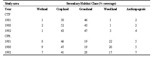
Table 3. Results of compositional analysis.